

La Niña isn’t here yet, but the influential pattern is still favoured to form as we head into the heart of winter across the northern hemisphere.
That’s the word from experts with the U.S. Climate Prediction Center (CPC) as they continued a La Niña watch through the remainder of November.
DON’T MISS: Will winter redeem its reputation? A sneak peek at winter 2024-25

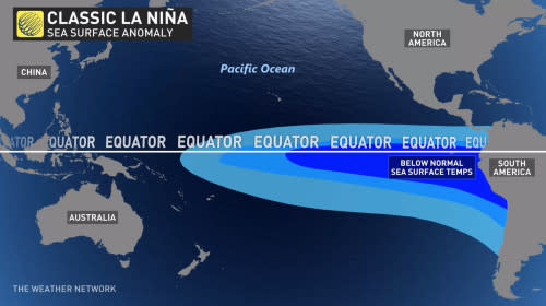
Forecasters monitor sea surface temperatures around the equator in the eastern Pacific Ocean for periods of above- or below-seasonal readings.
A spell of water temperatures at least 0.5°C warmer than normal for about seven consecutive months qualifies as an El Niño, while a similar stretch of sea surface temperatures at least 0.5°C below normal constitutes a La Niña event.
Temperatures in this section of the ocean have remained within a few tenths of a degree of normal this month, meaning that we’re in a neutral pattern where neither El Niño nor La Niña are present.


If this La Niña event forms as expected, it’s likely to be a weak one, the CPC said on Thursday. “A weak La Niña would be less likely to result in conventional winter impacts,” the experts added.
Predictions originally called for La Niña to develop over the summer, but it’s likely that warmer-than-normal ocean waters combined with unexpected wind shifts are responsible for persistently delaying the arrival of this pattern of cooler waters.
RELATED: What does a ‘missing’ La Niña mean for Canada’s winter?
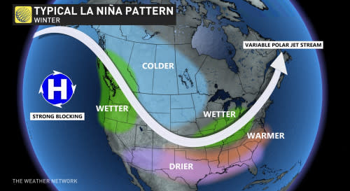
La Niña can have several noticeable effects on Canadian winters. During a typical event, below-seasonal temperatures are common in Western Canada while an active storm track would likely build over the Great Lakes and Eastern Canada.


What could that mean for the season ahead? Lots of factors drive overarching patterns across Canada during the winter months. La Niña and El Niño are just one part of the puzzle. “Whether or not we get a declaration is not that significant to our winter forecast,” said Dr. Doug Gillham, a meteorologist for The Weather Network.
“The atmosphere does not wait for official declarations to start being impacted by an event,” Dr. Gillham said.
He added: “The location of the coolest water relative to normal is actually more important to the winter forecast than the strength of the event—or whether there is ever an official declaration.”
Stay tuned for the launch of The Weather Network’s official winter forecast on Wednesday, Nov. 27, to learn more about what you can expect in the weeks and months ahead.